According to the weather report and update of PAGASA, issued at 5:00 AM, October 20, 2016, It is expected to exit the landmass via Ilocos Norte between 8-10 this morning.
Bagyong Lawin has slightly weakened while traversing Apayao Province.
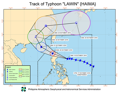
At 4:00 AM today, the eye of Typhoon "LAWIN" was located based on all available data in the vicinity of Kabugao.
Signal Warning #4
TCWS #4 (171-220 kph Expected in 12 hours)
Cagayan, Isabela, Apayao, Abra, Ilocos Norte, Ilocos Sur, Mt. Province, Kalinga, Ifugao and Calayan Group of Islands
Signal Warning #3
TCWS #3 (121-170 kph Expected in 18 hours)
La Union, Benguet, Nueva Vizcaya, Quirino and Northern Aurora
Signal Warning #2
TCWS #2 (61-120 kph Expected in 24 hours)
Batanes Group of Islands, Pangasinan, Rest of Aurora, Tarlac, Nueva Ecija and Northern Zambales
Signal Warning #1
TCWS #1 (30-60 kph Expected in 36 hours)
Rest of Zambales, Bulacan, Bataan, Pampanga, Rizal, Quezon Province including Polillo Islands, Cavite, Laguna, Batangas and Metro Manila
NOTE: The next weather bulletin update of PAGASA to be issued at 8:00 AM today.
source: Dost_pagasa
According to the weather report and update of PAGASA, issued at 11:00 AM, 19 October 2016. Bagyong Lawin further intensified and continues to pose an impending threat Over Cagayan - Isabela Area.
It is expected to make landfall over Cagayan - Isabela Area late tonight (11:00 PM) up to tomorrow early morning (Oct. 20), (2:00 AM) then will cross Apayao and Ilocos Norte.
Signal Warning #3
Rest of Cagayan, Apayao, Ilocos Sur, Mt. Province, Ifugao, Quirino and Northern Aurora
Signal Warning #2
Calayan Group of Islands, La Union, Benguet, Nueva Vizcaya, Pangasinan, Nueva Ecija, Rest of Aurora and Tarlac
Signal Warning #1
Batanes Group of Islands, Zambales, Pampanga, Bulacan, Bataan, Northern Quezon Including Polillio Islands, Metro Manila, Rizal, Cavite, Laguna, Camarines Norte, Camarines Sur and Catanduanes
As of 10:00 AM in the morning today the eye of the Typhoon was located at East of Casiguran, Aurora. Strength Maximum sustained winds of up to 220 kph near the center and gustiness of up to 305 kph.
Forecast Movement Forecast to move West Northwest at 26 kph.
Stay tuned and be updated for next weather report by liking our page.

source: Dost_pagasa
According to the weather report and update of PAGASA, issued at 8:00am in the morning of October 16, 2016. The eye of the Typhoon "Karen" was located in the vicinity of Binalonan, Pangasinan with maximum sustained winds of up to 130 kph near the center and gustiness of up to 220 kph.
Based on their forecast, Typhoon Karen forecast to move West Norwest at 22 kph.
Signal Warning #3 (121-170 kph Expected in 18 hours):
- Pangasinan
- Northern Zambale
- Tarlac
- La Union
- Benguet
Signal Warning #2 (61-120 kph Expected in 24 hours):
- Nueva Ecija
- Aurora
- Nueva Vizcaya
- Quirino
- Ilocos Sur
- Mt Province
- Ifugao
- Rest of Zambales
- Pampanga
- Bataan
Signal Warning #1 (30-60 kph Expected in 36 hours):
- Southern Isabela,
- Bulacan,
- Rizal
- Metro Manila
- Northern Quezon including Polilio island
- Ilocos Norte,
- Abra,
- Kalinga
- Southern Apayao
- Cavite
- Batangas
- Laguna
Stay tuned and be updated for next weather report by liking our page.